Презентація "The United Kingdom of Great Britain and Northern Ireland"


The United Kingdom of Great Britain and Northern Ireland. Prepared9th grade student. Margarita Melnyk
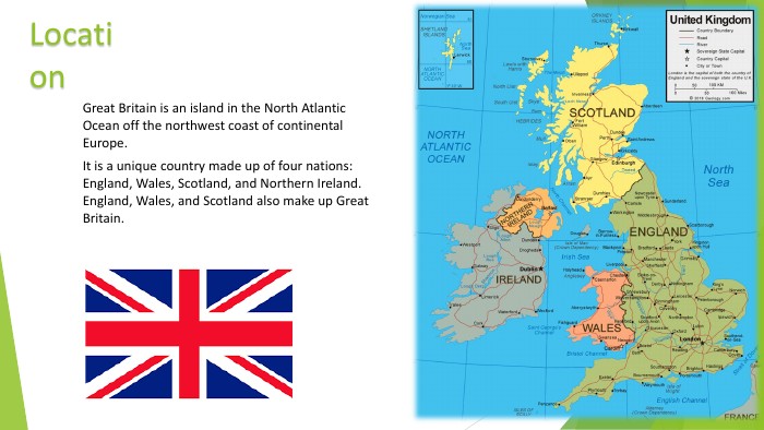
Location. Great Britain is an island in the North Atlantic Ocean off the northwest coast of continental Europe. It is a unique country made up of four nations: England, Wales, Scotland, and Northern Ireland. England, Wales, and Scotland also make up Great Britain.
Other names Official name United Kingdom of Great Britain and Northern Irelandabbreviated - United Kingdom or Great Britain
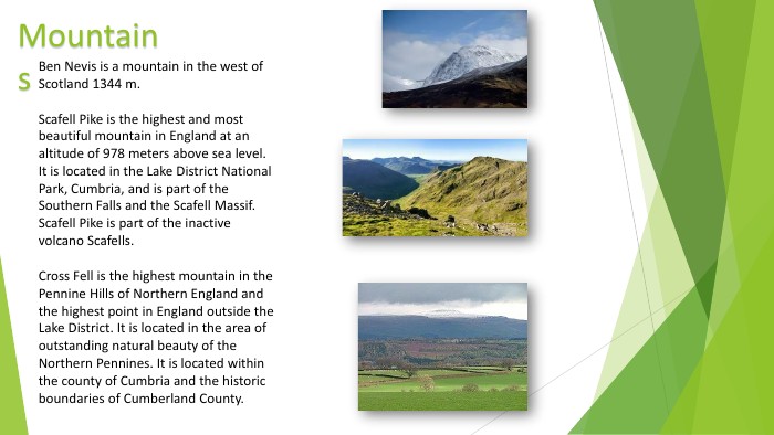
Mountains. Ben Nevis is a mountain in the west of Scotland 1344 m. Scafell Pike is the highest and most beautiful mountain in England at an altitude of 978 meters above sea level. It is located in the Lake District National Park, Cumbria, and is part of the Southern Falls and the Scafell Massif. Scafell Pike is part of the inactive volcano Scafells. Cross Fell is the highest mountain in the Pennine Hills of Northern England and the highest point in England outside the Lake District. It is located in the area of outstanding natural beauty of the Northern Pennines. It is located within the county of Cumbria and the historic boundaries of Cumberland County.
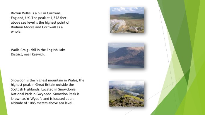
Brown Willie is a hill in Cornwall, England, UK. The peak at 1,378 feet above sea level is the highest point of Bodmin Moore and Cornwall as a whole. Walla Craig - fall in the English Lake District, near Keswick. Snowdon is the highest mountain in Wales, the highest peak in Great Britain outside the Scottish Highlands. Located in Snowdonia National Park in Gwynedd. Snowdon Peak is known as Yr Wyddfa and is located at an altitude of 1085 meters above sea level.

People{21 E4 AEA4-8 DFA-4 A89-87 EB-49 C32662 AFE0}Ethnic group. Number%White British50 366 49785,67 %White (other)3 096 1695,27 %Indians1 053 4111,8 %Pakistanis977 2851,6 %The Irish691 2321,2 %Mixed race677 1171,2 %African Caribbean565 8761,0 %Black Britons485 2770,8 %Bangladesh283 0630,5 %Other Asians (non-Chinese)247 6440,4 %The Chinese247 4030,4 %Other230 6150,4 %Black (other)97 5850,2 %
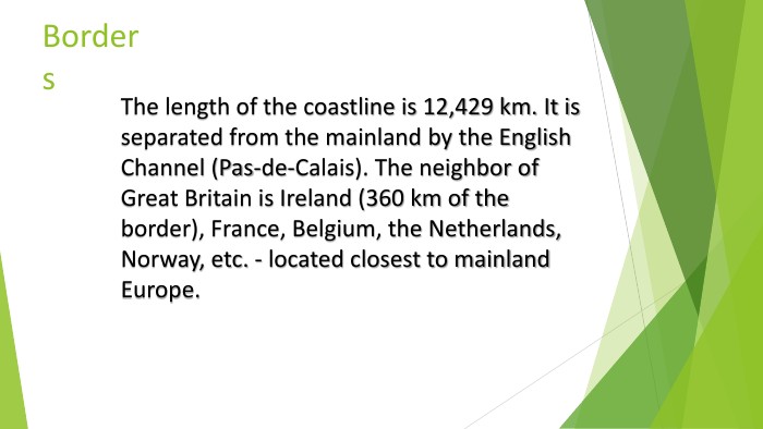
Borders. The length of the coastline is 12,429 km. It is separated from the mainland by the English Channel (Pas-de-Calais). The neighbor of Great Britain is Ireland (360 km of the border), France, Belgium, the Netherlands, Norway, etc. - located closest to mainland Europe.
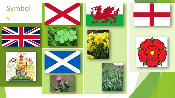
Symbols
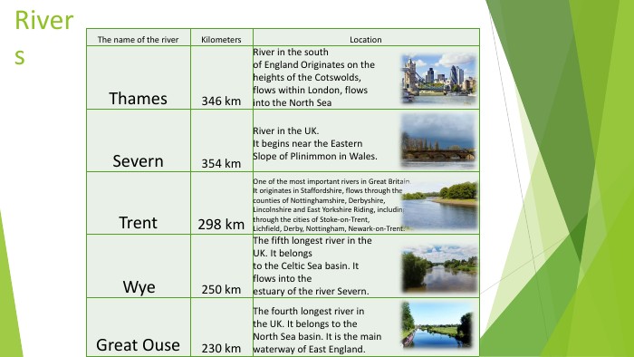
Rivers{8 A107856-5554-42 FB-B03 E-39 F5 DBC370 BA}The name of the river. Kilometers. Location. Thames346 km. River in the southof England Originates on theheights of the Cotswolds,flows within London, flowsinto the North Sea. Severn354 km. River in the UK. It begins near the Eastern. Slope of Plinimmon in Wales. Trent298 km. One of the most important rivers in Great Britain. It originates in Staffordshire, flows through thecounties of Nottinghamshire, Derbyshire, Lincolnshire and East Yorkshire Riding, includingthrough the cities of Stoke-on-Trent,Lichfield, Derby, Nottingham, Newark-on-Trent. Wye250 km. The fifth longest river in the UK. It belongsto the Celtic Sea basin. Itflows into theestuary of the river Severn. Great Ouse230 km. The fourth longest river inthe UK. It belongs to the. North Sea basin. It is the mainwaterway of East England.
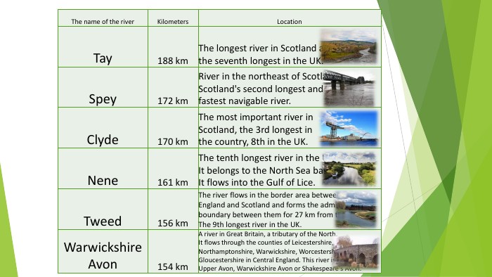
{8 A107856-5554-42 FB-B03 E-39 F5 DBC370 BA}The name of the river. Kilometers. Location. Tay188 km. The longest river in Scotland and the seventh longest in the UK. Spey172 km. River in the northeast of Scotland. Scotland's second longest andfastest navigable river. Clyde170 km. The most important river in. Scotland, the 3rd longest inthe country, 8th in the UK. Nene161 km. The tenth longest river in the UK. It belongs to the North Sea basin. It flows into the Gulf of Lice. Tweed156 km. The river flows in the border area between. England and Scotland and forms the administrative boundary between them for 27 km from the mouth. The 9th longest river in the UK. Warwickshire Avon154 km. A river in Great Britain, a tributary of the North. It flows through the counties of Leicestershire,Northamptonshire, Warwickshire, Worcestershire and. Gloucestershire in Central England. This river is also called. Upper Avon, Warwickshire Avon or Shakespeare's Avon.
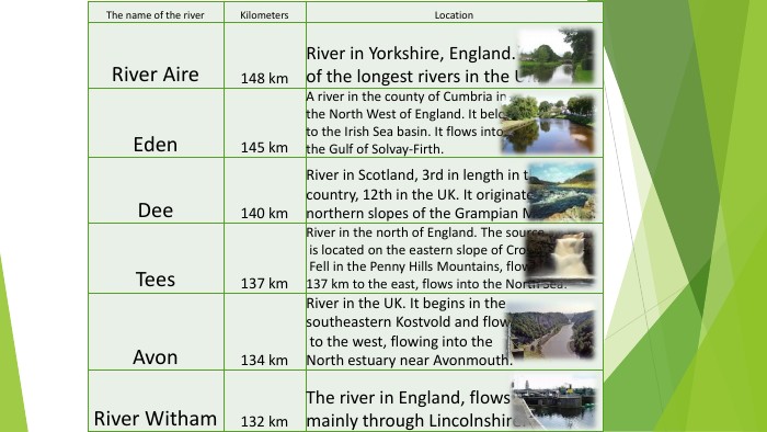
{8 A107856-5554-42 FB-B03 E-39 F5 DBC370 BA}The name of the river. Kilometers. Location. River Aire148 km. River in Yorkshire, England. One of the longest rivers in the UK. Eden145 km. A river in the county of Cumbria in the North West of England. It belongs to the Irish Sea basin. It flows into the Gulf of Solvay-Firth. Dee140 km. River in Scotland, 3rd in length in the country, 12th in the UK. It originates on the northern slopes of the Grampian Mountains. Tees137 km. River in the north of England. The source is located on the eastern slope of Cross Fell in the Penny Hills Mountains, flows for 137 km to the east, flows into the North Sea. Avon134 km. River in the UK. It begins in the southeastern Kostvold and flows 120 km to the west, flowing into the. North estuary near Avonmouth. River Witham132 km. The river in England, flows mainly through Lincolnshire.
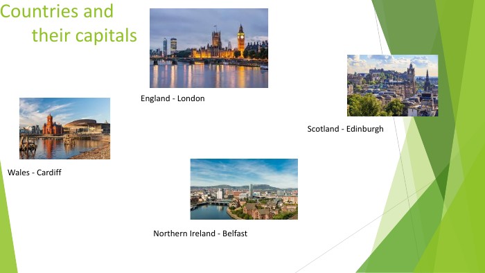
Countries and their capitals. England - London. Wales - Cardiff. Scotland - Edinburgh. Northern Ireland - Belfast
Thank you for your attention!

про публікацію авторської розробки
Додати розробку