Meet Great Britain. The Geographical Position of the Country
Система уроків на тематику “”The United Kingdom of Great Britain and Northern Ireland. The country and its capital.” з використанням різноманітних фотоматеріалів, мультимедійної презентації та запитань для географічної вікторини.

Meet Great Britain. The Geographical Position of the Country
Goals:
- to give students basic information about the subject they are going to learn about;
- to inform students about the geographical position of the UK;
- to enrich the outlook;
- to develop skills of listening, reading, speaking and writing;
- to teach students to listen carefully, to summarize, to work in groups and individually.
Equipment: the maps of the UK, the texts, cards.
The procedure:
Warming-up.
Each student gets the card with the riddle and the number (1-12). Their task is to guess the word and to write the first letter of it on the blackboard in the square marked by the number the student has in his/her card.
|
G1 |
R2 |
E3 |
A4 |
T5 |
B6 |
R7 |
I8 |
T9 |
A10 |
I11 |
N12 |
(Students guess the riddles, go to the blackboard and write the letters as far as they know the answer. If there are difficulties, the class helps. 4 min)
The riddles
- It is green and everywhere on the ground seen. (Grass)
- It is a very beautiful sweet smelling flower, a flower of love, but with thorns. (Rose)
- This is the biggest animal in the world that doesn’t live in water. (Elephant)
- This fruit grows on an apple-tree. (Apple)
- A hot drink that is made of leaves and is very popular with British and all over the world. (Tea)
- The animals that can fly. (Birds)
- In Ukraine it’s the Dnipro, in Britain it’s the Thames. What’s this? (River)
- It is cold and very tasty. It can be vanilla, chocolate and with jam. (Ice cream)
- A person who teaches you at school. (Teacher)
- They also live on the earth but they are not people. (Animals)
- The international computer net. (Internet)
- 1,2,3,4,5… They are … (Numbers)
Now you know the topic we are going to speak about. It is Great Britain.
I really have much to tell you and there will be a series of lessons dedicated to Britain. Today we shall learn basic facts about this country and especially about its geography. And at the end of the lesson there will be a short test in order to check your work. OK! Let’s go ahead!
First look at the sentence.
"Great Britain" has several different names, some people say "Britain", or "the United Kingdom", or just "the UK".
How many names of the country are mentioned?
What do you think is the official name of the state?
What is the abbreviation?
Remember to use the article where necessary. If the name of the state consists of several words, it is used with the article “the”: The United Kingdom. Great Britain is the name of an island, that’s why it is used without an article. (2 min)
Now when you know the name of the state, look at the map of it. Listen to a summary and then be ready to correct the mistakes in the sentences. (4 min)
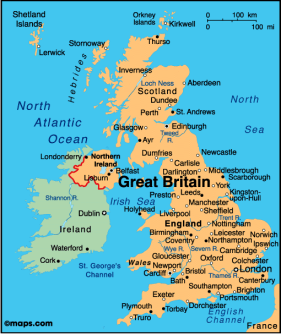 There are four different countries in the United Kingdom: England, Scotland, Wales and Northern Ireland. Altogether more than 56 million people live in Britain, many of them in big industrial cities like London, Liverpool and Manchester. Northern Ireland is situated in the northern part of Ireland. The territory of the United Kingdom is about 244 square kilometers and it takes the 75th place among other countries in the world. The capital of the country is London.
Now look at the sentences and correct them if necessary.
- There are five different countries in the United Kingdom.
- Altogether more than 56 million people live in Britain.
- Northern Ireland is situated in the northern part of Britain.
- The territory of the United Kingdom is about 422 square kilometers.
- The capital of the country is London.
OK. Let’s move on and add some facts about the geographical position of the state. Now, can I ask you to make three groups? Each group gets:
- the geographical map of the UK;
- short information about mountains, rivers or waters that wash Great Britain;
- new words with the transcription to help you to read new geographical names.
Please read the texts and get ready to tell the class what you have learned. Remember that everybody has to tell us at least one sentence. While you work I come and help with the pronunciation of the new words. So, begin, you have some minutes. (5 min)
The task for group 1:
Great Britain is separated from the continent by the English Channel, the narrower part of which is called the Strait of Dover. The British Isles are surrounded by the shallow waters of the Irish Sea and the North Sea, the North Channel and the Atlantic Ocean. Britain is comparatively small, but there is hardly a country, in the world where such a variety of scenery can be found.
The English Channel - пролив Ла-Манш
The Strait of Dover- пролив Па-де-Кале
British Isles- Британські острови
The Irish Sea- Ірландське море
The North Sea- Північне море
The North Channel- Північний пролив
The Atlantic Ocean- Атлантичний океан
The task for group 2:
Great Britain can be divided into two parts: Lowland Britain in the south and east, and Highland Britain in the North and West. The most important mountain territories are those located in the north of Scotland. Geologically these North West Mountains and the Grampians are among the oldest in the world. The highest peak is Ben Nevis (1343 m.). In the centre of England is a range of mountains called the Pennines. The Cambrian Mountains occupy nearly the whole of Wales. The highest peak there is Snowdon (1085 m.).
Lowland Britain- Низинна Британія
Highland Britain- Гірська Британія
The North West Mountains- Північно-західні гори
The Grampians- Грампіанські гори
Ben Nevis- Гора Бен Невіс
The Pennines- Пенінські гори
The Cambrian Mountains- Кембрійські гори
Snowdon- Гора Сноудон
The task for group 3:
The rivers of the region are short and of no great importance as waterways. The longest of them are the Severn (354 km) and the Thames, which is 346 kilometers long. Other comparatively long rivers are: the Trent, the Tweed, and the Wye. Lakes are found in the Lake District in England and in the highlands of Scotland. One of the best known lakes is Loch Ness in Scotland, famous for its ‘Loch Ness Monster’.
The Severn- річка Северн
The Thames- річка Темза
The Trent- річка Трент
The Tweed- річка Туїд
The Wye- річка Уай
The Lake District- Озерний Край
Loch Ness- озеро Лох Несс
All right, it’s time to share information. Please, all members of the group 1 come to the blackboard and one by one tell us what you have learnt and show everything on the map. Then go group 2 and 3. (6 min)
(Students speak and listen to each other in order to get first outlook)
Now please, change the cards. Group 1 gets the task of group 3, group 2 of group 1, and group 3 of group 2. You had the opportunity to hear everything that is in the card, and now you will also read. And the task is to make up questions on the subject. When the group asks the other two groups answer. Don’t forget to use the maps. Let’s take turns. Group one is the first to ask. (5 min)
Good job! And now after intensive work I am sure you need some rest. Let’s play “Bingo!”. All the new geographical names are written on the blackboard. Draw a model for the game. As you remember it is a table of nine cells. Then put down some nine names in them. (5 min)
Example:
|
the Wye |
Ben Nevis |
Wales |
|
the Atlantic Ocean |
Britain |
the English Channel |
|
Loch Ness |
the Pennines |
the Irish Sea |
Now I read you the names and if you hear one from your table, cross it. If you have horizontal, diagonal, or vertical crossings, rise your hand and say “Bingo!”. The first is the gold winner and the second and the third are silver and bronze winners. (1 min)
The English Channel, the Lake District, the North West Mountains, the Atlantic Ocean, the Irish Sea, the Thames, Loch Ness, the Strait of Dover, Snowdon, British Isles…
Now tell me, what geographical names are the most difficult for you to read and remember? Let’s all together pronounce them again. (1 min)
(This activity helps the teacher to find out difficulties and help)
Good. And now I have a question. Why do we use some names with the article and the others without it? You do already know some of the rules. It will be great to remember them and to add some new ones. (2 min)
So, we use the article ‘the’ with:
- the chains of mountains;
- the channels, rivers, seas, oceans;
We do not use the article with:
- the names of the mountains;
- the names of the lakes;
- the names of the islands.
Now I propose to play the game. I pronounce geographical names without the article, and you repeat all together either with it or without. (2 min)
English Channel, Lake District, North West Mountains, Atlantic Ocean, Irish Sea, Thames, Loch Ness, Strait of Dover, Snowdon, British Isles, Great Britain, United Kingdom, Wye, English Channel…
Well, I think that you were really working hard at the lesson. We have learned many facts about this country. And if you were attentive, it would be easy for you to pass the test. Open your exercise-books and write down the word ‘Test’. It will be a multiple choice test. Choose ‘a’, ‘b’, or ‘c’. (5 min)
1. The United Kingdom consists of four different countries ….
- England, Scotland, Wales and Ireland.
- England, Scotland, Wales and Northern Ireland.
- Britain, Scotland, Wales and Northern Ireland.
2. Great Britain is separated from the continent by…
- the English Channel.
- the North Channel.
-
 the Irish Sea. The model of the map
3. The highest peak in Great Britain is …
- Ben Nevis.
- Snowdon.
- Loch Ness.
4. The longest rivers in the UK are …
- the Trent and the Tweed.
- the Wye and the Strait of Dover.
- the Severn and the Thames.
5. The British Isles are surrounded by the shallow waters of …
- the Irish Sea and the North Sea, the North Channel and the Indian Ocean.
- the Irish Sea and the Black Sea, the North Channel and the Atlantic Ocean.
- the Irish Sea and the North Sea, the North Channel and the Atlantic Ocean.
6. The population of the United Kingdom is …
- 48 mln people.
- 56 mln people.
- 244 mln people.
The final part
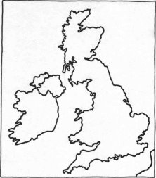
Well, that’s it for the first lesson. As a home assignment for the next lesson I give you the models of the maps where you can see only the shape of the country. Your task is to colour them, write all the geographical names there and speak about the geography of the UK using your own maps.
The teacher analyzes the lesson and student’s work, gives marks. (3 min).
Meet Great Britain. The Climate and Weather.
Goals:
- to inform pupils about the climate and weather in Britain;
- to learn more lexical units, to review known ones;
- to develop memory, imagination and logical thinking;
- to teach students to work individually with personal tasks;
- to exercise all kinds of language skills;
Equipment: the maps of the UK, pencils, felt pens and pieces of paper, the letter, cards, thematic pictures “Seasons and weather”.
The procedure:
Warming-up.
Fill in the missing words and read a tongue twister as fast and perfect as you can. (4 min)
Whether the weather is fine,
Or whether the … is not,
… the weather is cold,
Or whether the weather is …
Whether … weather,
Whatever the …,
Whether we like … or not.
(The key)
Whether the weather is fine,
Or whether the weather is not,
Whether the weather is cold,
Or whether the weather is hot
Whether the weather,
Whatever the weather,
Whether we like it or not.
(The exercise not only prepares tongues for English, but also develops logical thinking)
Speaking about changeable weather, the first thing that comes to my mind is Britain, which is famous all over the world for its weather. You already know that the UK is an island state and that means that it is surrounded by water. Look at the words and choose those that may characterize British weather. (2 min)
Changeable, nice, sunny, wet, rainy, cold, gloomy, damp, wonderful, snowy, windy, foggy, frosty, unpleasant, sunless, cloudy, warm, humid.
(We review lexical material and introduce new units. Students compose short sentences like: The weather in Britain is usually…, I think it is … and so on)
And now let’s see if you were right. Read a short text about the climate written on the blackboard and the weather in Britain. First pay attention at the note! (2 min)
32C – thirty two degrees above zero
10C – ten degrees below zero
Due to the geographic location of Great Britain the type of the climate there is oceanic. It is generally mild and damp. Average British temperatures do not rise above 32C in summer and do not fall below – 10C in winter. The two worst months in Britain are January and February. They are cold, wet and unpleasant. Summer months are rather cold and there can be a lot of rainy days. British fogs and changeable weather have worldwide reputation.
Well, these six sentences are rather informative. Look at them for a minute and try to remember. Then I shall clean some words and you’ll try to read the text filling them in.
(The teacher deletes the words that are easy to restore – one or two in each sentence. The pupils read sentence by sentence. Then it is possible to clean more words in order to make students remember the text) (5 min)
Great! Now let’s play ‘Weather Forecast’ game. One of you will be a tourist who wants to visit London tomorrow. He needs the weather forecast because he doesn’t know what clothes or things to take. Two other volunteers are his friends who have just heard the weather forecast. They will tell our tourist about it. And the rest of the group will be a team of the workers of the Met Office. They prepare weather forecast. (8 min)
(A tourist leaves the class for a minute; his two friends listen to the forecast. Then he comes in and friends retell the forecast for him. The Tourist tells the class what clothes he decided to take. Everybody is involved and interested. The activity develops speaking and listening)
And to make the task easier I have prepared the patterns for you. They are on the cards. Just read the first part of the sentence and add the second. The first is the student with the card number 1, then 2, and so on.
- Tomorrow the weather in London will be ….
- The temperature will be …
- In the morning we expect…
- But in the afternoon …
- The evening promises to be …
- Have a nice …
(Then comes the tourist and his friends try to tell him as detailed forecast as possible and he speaks about the things he is going to take.)
And I advise you to take a mackintosh with you.
Do you know what a mackintosh is? Of course, you do. It’s a raincoat. But do you know that the word "Mackintosh" is a surname? Listen… (2 min)
In 1823, in Scotland lived a man whose name was Charles Mackintosh. It often rained in Great Britain, and Charles Mackintosh got wet quite often.
One day he rubberized his coat and it became waterproof. Many of his friends liked his coat and asked him to rubberize their coats too. Soon many people began to rubberize their coats and they called those coats "mackintoshes".
- So, what does the word mean?
- Was Mackintosh a surname of a Scot or English?
- Why did he decide to rubberize his coat?
Good job! It’s time to relax after it. There are pencils, felt pens and pieces of paper on your desks. Please, relax, forget that you have a lesson, close your eyes and think about … the wind – sometimes gentle, warm, pleasant and sometimes strong or even dangerous. Have you imagined it? And now I’d like to ask you … to draw it. Yes, draw. It will be interesting for you and me to see the pictures. And while you do it, listen to the poem: (3 min)
Who has seen the wind?
Neither you, nor I
But when the leaves hang trembling,
The wind is passing by…
Who has seen the wind?
Neither I, nor you
But when the trees bow down their heads,
The wind is passing through.
Well, show your pictures and comment them in a couple of words. (3 min)
Now you know not only about the geography of the UK but also about its climate and weather. By the way, yesterday I got the letter from one of my friends, Nina. She writes that her parents want to send her to Oxford to study English. And she writes, I cite:
I don’t want to go to England. It is washed by the Pacific Ocean. Right? And the Rocky Mountains do not protect from the winds from the ocean. I don’t like windy days….
And so on. Well, my friend is not an expert in British geography, as you see. But you are! Your home task was to speak about it using the map.
In order to make it fun, let’s play roles. (10 min)
While one student is at the map the other volunteer plays a teacher. The teacher listens very attentively and notes down all the mistakes made by the student.
OK, who’s going to tell us about the geographical location of Great Britain? Who wants to be a teacher?
Well, you know rather much about Britain for now. Of course this is only the beginning of your acquaintance, but a ‘good beginning makes a good ending’. The last activity for today’s lesson will be the following. Write a short answer to my friend, Nina, and tell her that she is a bit wrong. Write her about the UK and its weather. Begin with:
Dear Nina,
My name is …. Our teacher told us that you would study in England. How lucky you are! I am going to write you about this country.
Start writing here and continue at home. And tomorrow we shall send your letters to Nina. She will be happy to learn more about Great Britain. (5 min)
The final part
Thank you for your active work at the lesson! The marks are …
And one more thing. Bring dark blue, white and red cardboard and glue tomorrow, please. I have a surprise for you.
Meet Great Britain. The National Symbols.
Goals:
- to give students basic information about the national symbols of Britain;
- to inform students about the Queen and the Prime Minister of the UK;
- to enrich the outlook, to tell students about the way of life of British VIPs;
- to develop skills of listening, reading, speaking and writing.
- to develop creativeness.
Equipment: dark blue, white and red cardboard, glue, flags, pictures, a tape-recorder.
The procedure:
Warming-up.
As a warming-up exercise today I offer you to name three English words: three rows in the classroom and each row gives one word.
Example: trees, white, telephone
OK! And the task is to combine these words into one sentence. Any ideas?
Example: I saw that the trees were white with snow, took the telephone and called my friend to ask her to go for a walk.(3 min)
Well done! And now it’s time to get back to Britain. Let’s make two teams and have a short quiz. I shall register all your answers and then we’ll find out the winner. So, answer the questions, please. (5 min)
- What is the official name of the country?
- What is the population of it?
- What countries does it consist of?
- What is the capital of the UK?
- Why is Britain called an island state? And what waters wash it?
- Where are the Pennines situated?
- What mountains are there in Scotland?
- What is the highest peak of Britain?
- What rivers in Great Britain can you name?
- Describe the usual weather in Britain.
I see that you have good knowledge of the subject. And now it’s time to send the letters to Nina. It was your home task, as you remember. I have brought an envelope. Now we shall listen to a couple of them and the rest here. I’ll check them first and give you marks. (4 min)
And today we shall speak about the national symbols of the country and about its government.
Now, look here. I have brought you a flag. This is a national symbol of the United Kingdom of Great Britain and Northern Ireland. Have you ever seen it before? Read some statements about it. (3 min)
![[Flag of the United Kingdom]](/uploads/files/3789/4588/4608_html/images/4588.003.png)
![]() St. George's Cross,
St. George's Cross,
the flag of England
![]() St. Andrew's Cross,
St. Andrew's Cross,
the flag of Scotland
![]() St. Patrick's Cross,
St. Patrick's Cross,
the flag of Ireland
The flag is called the "Union Jack" or "Union Flag" and it is made up of three different national symbols: St. George’s Cross, St. Andrew’s Cross and St. Patrick’s Cross. St. David is the Patron Saint of Wales.
No mention has been made of the Welsh flag. The Welsh dragon was not incorporated into the Union Flag because Wales had already been united to England when the first version of the Union Flag was designed in 1606. It is, however, in common use. 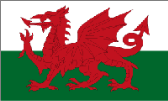
The main idea of the flag is to show the union or even the family of nations. The British are very proud of their flag.
Well and now it’s time to create. You have brought cardboard. We shall make British flags. Follow my instructions:
- First cut half of the standard sheet of blue cardboard;
- Cut two red crosses - St. George’s Cross and St. Patrick’s Cross;
- Glue St. Patrick’s Cross and then St. George’s Cross on white cardboard;
- Cut them out so that white will be at least half a centimeter visual from all sides and glue this block on blue.
Congratulations! All of you have flags. (10 min)
Now let’s write the description of the British flag. (5 min)Here is the plan:
- The name of the flag.
- The colour of the background.
- The number, the colour and the names of crosses.
As you probably know, the United Kingdom is a monarchy and the Queen is the head of state. Later I’ll tell you more about the Queen, but now it’s time to present the National Anthem of Britain. It is ‘God Save the Queen’. Text and tune may date back to the 17th century. When the British monarch is male it is ‘God Save the King’.
Listen to it. (2 min)
God save our gracious Queen,
Long live our noble Queen,
God save the Queen:
Send her victorious,
Happy and glorious,
Long to reign over us:
God save the Queen.
O Lord our God arise,
Scatter her enemies,
And make them fall:
Confound their politics,
Frustrate their knavish tricks,
On Thee our hopes we fix:
God save us all.
Thy choicest gifts in store
On her be pleased to pour;
Long may she reign:
May she defend our laws,
And ever give us cause
To sing with heart and voice
God save the Queen
Did you like the melody? Is it strong? patriotic? Speaking about the Queen, I can’t but tell you more about her Majesty and about one more VIP in Britain. Let’s read the text and watch some pictures: (5 min)

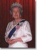 Now the head of the state is Queen Elizabeth II. She was crowned in 1952. The Queen is probably the wealthiest and the busiest woman in the world. She meets thousands of people every year. Her official London home is Buckingham Palace.
But the Queen is formally the head of the state. In practice the UK is ruled by the elected government with a Prime Minister at the head. Now the prime Minister of the state is Gordon Brown. 10, Downing Street is one of the most famous addresses in London, because this is the official residence of the Prime Minister.
Now please, say if the sentences are true or false:
- Now the head of the state is Queen Elizabeth I.
- She was crowned in 1972.
- Her official London home is Buckingham Palace.
- Now the prime Minister of the state is Tony Blair.
- 10, Downing Street is the official residence of the Prime Minister.
Now, look. Here is a small exercise for you. There are some spaces that you are to fill in using the words below. (6 min)
The British are very proud of their Queen. She is also the symbol of … like the flag and the song. When the Queen gets up in the morning, … people look after her. … starts her bath, one prepares her clothes, one feeds the Royal …. Two people bring her …. Every day for … minutes a musician plays Scottish music outside her room and the Queen reads The Times.
The key: Britain, seven, one, dogs, breakfast, fifteen.
The final part
Well done! And the lesson is almost over. Today we got acquainted with the symbols of the United Kingdom. The task for you will be to be able to answer my questions about them and also about the emblems of four countries. The information about them you’ll find in the text ‘British Emblems’, which I ask you to read and translate at home. Don’t forget to write out new words.
British Emblems
The different parts of Britain have their own emblems. They are all plants. In the 15-th century there was a series of wars in England, which were called The Wars of the Roses. They were between the Dukes of Lancaster and the Dukes of York. The emblem of Lancaster was the Red Rose and the emblem of York was the White Rose. The Dukes of Lancaster won, so the emblem of England is the Red rose.
The thistle, the national emblem of Scotland, was chosen because it saved the country from the enemy. This is what a legend says about it. In ancient times the Norsemen raided the east coast of Scotland intending to plunder it and settle in the country. The Scots took their stations behind the river Tay, the largest in Scotland. Not expecting the enemy before the next day and being weary and tired after a long march they pitched their camp and were resting. The Norsemen saw that no guards protected the camp so they crossed the river intending to take the Scots by surprise. On coming quite near they took off their shoes not to make noise. But one of the Norsemen stepped on a thistle and shrieked with pain. The alarm was given in the Scots camp and the Norsemen were put to flight. Scots, thankful for timely help, chose the thistle as their national emblem.
The leek and the daffodil are Welshmen’s national emblem. Welshmen all over the world celebrate (in March) St. David’s Day by wearing either leeks or daffodils. St. David is supposed to have lived for several years on bread and wild leeks, so the link between the leek and St. David is a strong one. The daffodil is also closely associated with St.David’s Day. It became an alternative to the leek as a Welsh emblem in the present century, because some thought the leek vulgar. The Welsh national flag is called Welsh dragon. It bears the red dragon on the white and green background.
The shamrock, the national emblem of the Irish, is proudly worn on St. Patrick’s Day, March 17. It is worn in memory of Ireland’s patron saint, who when explaining the idea of the Trinity to the Irish used the shamrock (a small white clover with three leaves on one stem) as an illustration of the mystery.
1

про публікацію авторської розробки
Додати розробку