Велика Британия. Географія країни.
Зозробка урока має на меті формувати загально географічні уявлення учнів про Велику Британію з залученнм учнів до інтерактивної діяльності
Тема : Географічний огляд Великої Британії
Навчально – практична мета:
1)активізувати лексику пов’язану з географічними поняттями
2) вдосконалити фонетичні навички вимови географічних назв
3) формувати загально географічні уявлення про Велику Британію, як основного носія мови, що вивчається.
4) залучити учнів до інтерактивної діяльності
Розвиваюча мета:
1) розвити соціокультурну компетенцію учнів через вивчення географії та природних пам’яток країни.
2) сприяти розвитку навичок роботи з картою та ілюстраціями,
3) розвити вміння аналізувати картографічні та статистичні матеріали ,
Виховна мета:
1) сприяти вихованню естетичного сприйняття країни
2) формувати загальнолюдського світогляду
Обладнання: малюнки ілюстрації з видами країни бейджики з іменами туристичних агентів
елементи оформлення туристичного бюро
Хід уроку
1) Привітання та оголошення мети та плану уроку. Слово вчителя:
You have studied the topic “The geographical outlook of GB”. And today we have experts who can check your knowledge. The best students can be awarded. They can get a prize.
2) Pupil 1 Hi! My name is Rosy Young. I’m a tour guide. I work in a travel agency

Your first task will be to read the words correctly
|
ocean sea / sea routes geography position weather continent climate weather mountains highlands lowlands land island coast area |
United Kingdom Great Britain Northern Ireland Atlantic Ocean British Isles Geographical position Official name Western coast English Channel North Sea Irish Sea Wales Strait of Dover Thames Severn |
3) The next task will be to answer the questions:
Geography of the United Kingdom of Great Britain and Northern Ireland
1. Where is Greenwich?
a) in England b) in Scotland c) in Wales d) in Ireland
2. What lake does the famous Scottish monster live in?
a) Loch Erne b) Loch Lomond c) Loch Ness d) Loch Dove
3. What is the longest river in Great Britain?
a) the Severn b) the Avon c) the Thames d) the Tyne
4. What is the name of the highest mountain in Wales?
a) Ben Nevis b) Snowdon c) Scaffel Pike d) Alps
5. What is the capital of Northern Ireland?
a) Cardiff b) Dublin c) Belfast d) London
6. What city in Britain has nickname “The Smoke”?
a) Edinburgh b) Cardiff c) London d) Aberdeen
7. Great Britain is divided into… .
a) 2 parts b) 3 parts c) 4 parts d) 5 parts
8. What natural resources bring the most profits to the British economy?
a) coal reserves b) oil reserves c) water reserves d) gold reserves
9. What is Britain famous for?
a) its rains b) its winds c) its fogs d) its cold
10. What are the best English resorts?
a) Bristol and Southampton b) Brighton and Bath
c) Leeds and Bradford d) Sunset Beach
4) Pupil 2: How do you think is Great Britain worth seeing and visiting?
Look at these illustrations.
Do you like the places you see?
Which place would you like to visit?
Pupil 3: Do you need some extra information about the place?
Agents can help you.
Туристичні агенти описують малюнки ілюстрації.
Pupil 2: Now you can come to the board and look at the photos.
Be ready to take part in a contest!
So now read the information and guess the place. Fill in the form.
- Учні опрацьовують речення:
Group ____________________
A) ______________ is an archipelago in northern Scotland. It comprises approximately 70 islands of which 20 are inhabited.
B) The _______________ are the most mountainous area of GB. It is an important tourist attraction.
C) ____________ is the highest mountain in the British Isles, standing at 1,344 m. Over 1000 people climb it every year.
D) Scotland is famous for its lochs (lakes). _____________ is the biggest. It is 39 kilometers long and 8 kilometers wide. It contains more fresh water than all the lakes in England and Wales combined.
E) Do you know there are national parks in Wales? ______________ is one of them.
The highest mountain is Snowdon (1085m). You can reach the top (7, 6 km) on foot or by train.
F) The _____________ is the longest river in the UK.
It is 354 km.
G) Did you know that GB and Ireland are surrounded by over six thousand smaller islands?
_______________ is 30 miles from England. It is the smallest island with building on it.
H) _______________ is well-known for its lakes, forests and mountains.
I) One of the most famous lake in Scotland is __________. It’s about a mile wide and it holds the legend of a infamous sea monster.
|
Lake District |
|
|
Snowdonia |
|
|
Loch Lomond |
|
|
Ben Nevis |
|
|
Highlands |
|
|
Severn |
|
|
Bishop Island |
|
|
Orkney |
|
|
Lock Ness |
|
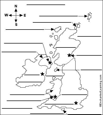
6) Tourist agent 3 The final task is to label the British Isles and at home make up a crossword to get the main prize –a trip to England!
Atlantic Ocean- the body of water in which the British Isles are located
Belfast- the capital of Northern Ireland
Cardiff- the capital of Wales
Celtic Sea- the sea south of Ireland
Dublin- the capital of Ireland
England the largest area in the United Kingdom; it is attached to Scotland and Wales
Edinburgh- the capital of Scotland
English Channel- the body of water off southern England which separates it from France
Hebrides- islands off the northwest coast of Scotland
Ireland- (the Republic of Ireland) - a country west of England across the Irish Sea (not part of the United Kingdom)
Irish Sea- the body of water that separates England and Ireland
Isle of Man- an island in the Irish Sea
Isle of Wight- an island off the southern coast of England
London- the capital of England (and the capital of the United Kingdom)
North Sea- the body of water northeast of the British Isles separating it from northwestern Europe
Northern Ireland- a part of the United Kingdom bordering the Republic of
Ireland on the northeast
Orkney Islands- islands off the northeast coast of Scotland
Scotland- a part of the United Kingdom bordering England on the north
Shetland Islands- islands far off the northeast coast of Scotland
Wales- a part of the United Kingdom bordering England on the southwest 


про публікацію авторської розробки
Додати розробку
